Ith-Hils-Weg

- 23:30 h
- 81.30 km
- 1,970 m
- 1,970 m
- 114 m
- 481 m
- 367 m
- Start: Coppenbrügge
- Destination: Coppenbrügge
Welcome to the Ith-Hils-Weg!
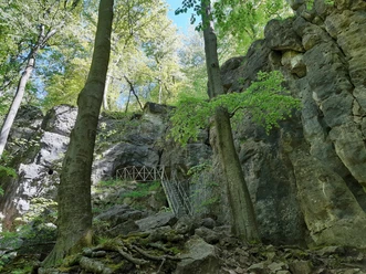
Along historic towers and cult sites, lake landscapes, and bizarre rock formations as well as caves, the well-signed quality Ith-Hils-Weg is a special experience even for experienced hikers. On the 81 kilometer long circular route, you can experience the diverse and varied landscape with the Ith and Hils ridges as well as other elevations up close. This path is characterized by a particularly beautiful, natural track. Along ridge trails the path leads to spectacular cliffs and natural-historical special features with wide views over the land and fascinating insights into the history of this region. From Coppenbrügge the Ith-Hils-Weg runs along the Ith ridge to the southeast to Holzen, a district of the market town Eschershausen in the Solling-Vogler Region. From here it goes east through the Hils to the town of Grünenplan and then again southeast to Kaierde. Behind Kaierde the Ith-Hils-Weg turns north in a curve to the village Delligsen and then follows northwest the Steinberg and the Reuberg to the Lippoldshöhle cave. Over heights the trekking route on the Ith-Hils-Weg continues northeast through Salzhemmendorf to Lauenstein and then back through the Ith to Coppenbrügge. The entire route can also be well explored in seven individual stages. Each stage offers very special highlights along the way. Be it natural monuments, viewing rocks, historic towers, museums, or UNESCO World Heritage: The Ith-Hils-Weg offers unique holiday experiences in the Eastern Weser Uplands. All stages start at hiking car parks with large information boards. At these starting and end points as well as in the respective villages, there are accommodation and dining options. Numerous open-air and indoor pools and special bathing facilities such as the Lauenstein natural adventure pool, a spacious recreational lake area, and the Ith brine thermal baths as a wellness paradise offer opportunities for year-round relaxation and recreation in the Ith-Hils region alongside hiking enjoyment.
Note: Information on the closure of the Ith-Hils-Weg: Due to logging work, the section between Lutherplatz and Kaierde is closed for approximately 4-8 weeks. A detour is signposted on site. The corresponding GPX track for the detour can be found here. Thank you for your understanding! We wish you a nice route on the Ith-Hils-Weg


Waypoints
Good to know
Pavements
Best to visit
Directions
The stages are as follows:
Stage 1: Coppenbrügge - Humboldtsee, length: 18.9 km, duration: about five and a half hours, START: Coppenbrügge, Felsenkeller END: Wallensen, Waldhotel Humboldt
Stage 2: Humboldtsee - Eschershausen, length: 17.3 km, duration: about five hours, START: Wallensen, Waldhotel Humboldt, END: P+R Eschershausen
Stage 3: Eschershausen - Grünenplan, length: 13.0 km, duration: about four hours, START: P+R Eschershausen, END: Grünenplan, Obere Hilsstraße
Stage 4: Grünenplan - Delligsen, length: 14.0 km, duration: about four hours, START: Grünenplan, Obere Hilsstraße, END: Freibad Delligsen
Stage 5: Delligsen - Duingen, length: 18.8 km, duration: about five and a half hours, START: Freibad Delligsen, END: Duingen - town
Stage 6: Duingen - Salzhemmendorf, length: 15.7 km, duration: about four and a half hours, START: Duingen - town, END: Salzhemmendorf - town
Stage 7: Salzhemmendorf - Coppenbrügge, length: 10.1 km, duration: about three hours, START: Salzhemmendorf - town, END: Coppenbrügge - town
Equipment
Sturdy footwear, rainwear if needed, and sufficient water
Directions & Parking facilities
From the north
via the A7, A352 and A2 to Lauenau then onto B442
From the east
via the A2 to Lauenau then onto B442
From the south
via the A7 to Northeim (exit 69-Northeim-Nord) then follow B3, Lange Str., L462 and B1 to Coppenbrügge
From the west
via the A2 to Lauenau then onto B442
or via the A30 and A2 to Lauenau then onto B442
Hiking car park: Felsenkeller 4, 31863 Coppenbrügge
Quiet parking spot with a view of the Ith and a hiking information board. A outdoor pool is nearby.
Coppenbrügge has a train station.
From Hildesheim you can reach Coppenbrügge with the NordWestBahn towards Bünde (Westf.).
From the south you can easily reach Coppenbrügge via Hildesheim.
From Hameln you can reach Coppenbrügge with the NordWestBahn towards Hildesheim main station.
From the north you can easily reach Coppenbrügge via Hannover and Hameln. (There is an S-Bahn to Hameln.)
Additional information
www.ith-hils-weg.de
Literature
Here you can find general information and an overview of the Ith-Hils-Weg for download in PDF format.
You can also get this and other brochures about the Eastern Weser Uplands region at the tourist information offices in Bad Münder, Coppenbrügge, and Salzhemmendorf.
You can also order them online anytime here.
License (master data)
Weserbergland Tourismus e.V.

Author´s Tip / Recommendation of the author
The Lauenstein natural adventure pool, a spacious leisure lake area, and the Ith brine thermal baths offer you relaxation and recreation.
Safety guidelines
Please note: At some spots good surefootedness is required. Divide the route into stages according to your strength. When wet, some spots can be slippery.
Map
Hiking map - Ith-Hils-Weg
The hiking map for the Ith-Hils-Weg shows you the route on the nearly 80 km long circular hiking trail over Ith and Hils, scale: 1:50,000, 3.50 €
Nearby


Download GPX file