Harzer-Hexen-Stieg - full route

- 25:00 h
- 96.23 km
- 1,571 m
- 1,615 m
- 173 m
- 1,141 m
- 968 m
- Start: Osterode
- Destination: Thale
The best way to get to know the full diversity of the Harz is to cross it on the Harzer-Hexen-Stieg.
Since 2005, the "Quality Route Walkable Germany" has connected the towns of Osterode in Lower Saxony and Thale in Saxony-Anhalt. Ninety-four kilometers that lead the hiker through almost all types of landscapes and pick up sights and interesting things in the region:
The historic mining has already been mentioned. The Harz was almost treeless at times. The wood was needed for the expansion of the tunnels, but especially for the production of charcoal – the most important energy source for smelting the ores. Charcoal piles and charcoal burners' huts were found everywhere.
Water powered the mining, the ditches and ponds accompany the Harzer-Hexen-Stieg over long distances. But water also plays an important role in other ways. For the Harz itself, but also for its surrounding area. Reservoirs collect and secure the vital water, protect against floods, and supply drinking water far into northern Germany.
The legendary mountain wilderness of the Harz National Park, Germany’s first and only cross-state national park, transports you to places where nature may still be nature – and also feels like that: inspiring for body and mind. This is the home of dwarfs; witches and devils hide behind gnarled tree stumps.
The Harzer-Hexen-Stieg itself is also cross-state. What today is the inconspicuous border between Lower Saxony and Saxony-Anhalt was, until 20 years ago, part of the Iron Curtain. It mercilessly separated East and West and cut right through the Harz. Today, the Green Belt runs along the former inner-German border. A sanctuary for rare plants and animals.
The Brocken became a symbol of division. Omnipresent but unreachable was its often foggy and storm-beaten summit. Only the Stasi and Russian military had access to the most important listening post in the West. The Brockenhaus at the summit bears witness to the history of this unique mountain.
Once again, nature dominates everything: From the Brocken downwards, the Bode defines the course of the path. Warm and cold Bode rivers spring from the swamps there, unite, flow through dense forests and across open meadows to then flow towards the grand highlight of the hike:
the Bode Valley. The deepest rocky valley in Central Europe north of the Alps. Hundreds of meters high rock walls rise, the water rushes through swirling and roaring. What started idyllically ends spectacularly.
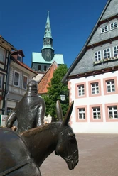
And here we meet them again. The myths and legendary figures of the Harz. High above the Bode Valley, on the Hexentanzplatz or opposite it on the Rosstrappe, where the hoofprint of Brunhild's horse, fleeing from the knight Bodo, is deeply carved into the rock. She lost her crown during the leap over the Bode Gorge. It still lies today at the bottom of the river ...


Good to know
Pavements
Best to visit
Directions
The main route of the "Harzer-Hexen-Stieg" runs via Osterode - Buntenbock - Altenau - Torfhaus - Brocken - Drei-Annen-Hohne - Königshütte - Altenbrak - Bode Valley - Thale.
Between Königshütte and Altenbrak, 2 alternatives are indicated:
a) Hasselfelde - Köhlerhütten - Altenbrak
b) Rübeland - Wendefurth - Altenbrak
Anyone who wants to avoid the Brocken hikes from Torfhaus to St. Andreasberg passing via Braunlage to Königshütte.
Additional information
The Harzer-Hexen-Stieg is supported by Harz Energie, the savings banks along the route, and Blankenburger Wiesenquell.
Literature
Harzer-Hexen-Stieg - official hiking guide
Route description in both directions, 5 stages, 2 alternative routes, elevation profiles, graphics, overview map, dining and accommodation options, GPS tracks, stamp stations | 80 pages, size 120 x 190 mm | Schmidt-Buch-Verlag
Available at www.harzinfo-shop.de.
License (master data)
Harzer Tourismusverband

Safety guidelines
Map
Nearby